BECAUSE HISTORY MATTERS, WE NEED YOU! BECOME A MEMBER AND HELP US PRESERVE YOUR LOCAL HISTORY. CLICK THE JOIN BUTTON BELOW.

Mundaring District
The Shire of Mundaring is a local government area in the eastern metropolitan region of Perth. It is a large district that encompasses the areas of Bailup, Beechina, Bellevue, Boya, Chidlow, Darlington, Glen Forrest, Gorrie, Greenmount, Helena Valley, Hovea, Mahogany Creek, Midvale, Mount Helena, Mundaring, Mundaring Weir, Parkerville, Sawyers Valley, Stoneville, Swan View, The Lakes and Wooroloo.
Exploration of the range of hills to the east of the Swan River plain began shortly after the British Government established the Swan River Colony in 1829.

Exploration of the range of hills to the east of the Swan River plain began shortly after the British Government established the Swan River Colony in 1829, largely because of the pressing need to find suitable land for flocks and crops. These explorations led to the settlers finding the broad valley of the Avon River where several towns were laid out. One of these was the town of York.
A road (today's Great Eastern Highway) connecting York with Guildford was soon surveyed and traffic was soon passing backwards and forwards between the two settlements. A wayside inn, The Prince of Wales, was established at Mahogany Creek in 1844, providing a welcome stopping point for travellers.
The discovery of gold in the eastern district of Yilgarn in the late 1880s led to a large influx of prospectors hoping to strike it rich in this new area. It also provided Western Australia with some much needed capital to commence building infrastructure.
The construction of the Eastern Railway line, which ran between Guildford and, eventually, Kalgoorlie passed directly through the district of Mundaring. The first section of this line was constructed in 1884 and small settlements began to spring up along this line. This line had some steep curves and gradients in places, which often led to trains leaving the tracks. To solve this problem, an additional line was built to the north of this original line. This new track, which was opened in 1896, also boasted the state's first railway tunnel. As with the southern track, settlements were also established along this route.
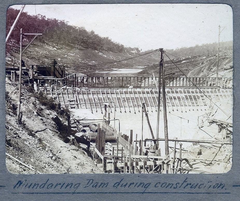
The district received an important boost when the Goldfields Water Supply Scheme was completed in 1903. The dam that was constructed across the Helena River, known today as Mundaring Weir, became the primary water supply to the dry eastern goldfields and later the eastern agricultural districts.

Bailup
Bailup is located on Toodyay Road, north east of Noble Falls. The name first appears as 'Baylup' on government surveyor Philip Chauncy's survey plans in the 1840s. An Inn and a Police Station existed in the location between 1840 - 1870 and serviced travellers using the Toodyay Road. The suburb of Bailup was created during the 1990s. No photographs exist for Bailup in the Society's collection.
Beechina
The townsite of Beechina was gazetted in May 1904 on what had previously been Reserve 8595. Sixteen lots classed as 'Suburban Lands for Cultivation' and 'Working Men's Blocks, were initially offered for sale. The new townsite was located adjacent to the Eastern Railway line and a siding was later erected towards the northern end of the town.
Bellevue
The area takes its name from Edward Robinson's farm, which in its day was considered to be a model farm. Robinson built his homestead in 1887, calling it Belle View. The bricks for the house were made on site from the local clay deposits. This natural resource led to commercial brickmaking in the area in the mid 1890s with the largest concentration of brickyards in WA being at one stage clustered near the Bellevue railway station. As a result Bellevue grew phenomenally.
Boya
Boya's history is bound up with that of neighbouring Darlington. In July 1901 dozens of iron and hessian huts sprung up near a site to the south-west of Darlington village chosen for a quarry.
Chidlow
Originally known as Chidlow's Well, the earliest official townsite to be declared within the Shire takes its name from a watering place first located and used by William Chidlow who came as a servant to Western Australia in 1831. The Blackbutt that shaded Chidlow's Well became an overnight campsite for travellers to Northam from the mid 1830s.
Darlington
As early as the 1840s settlers on their way to York made a track through this area but the route was so rocky and rugged it was seldom used and the southern foothills were left undeveloped. In 1883 Dr Alfred Waylen, the colony's principal Medical Officer, purchased three lots in this rugged area, which he planted out with vines. He named his property 'Darlington'.
Glen Forrest
Glen Forrest has had a long association with the timber industry but the area wasn’t known by this name until 1915. Timber tracks extended south from the York Road as early as the 1840s but permanent settlement had to wait until the late 1870s when Alfred Smith established a steam driven sawmill in the Mundaring District.
Gorrie
Gorrie was the name given to the new suburb created in 1997 to an area to the east of Sawyers Valley in the Shire of Mundaring. The name was obtained from nearby Mt Gorrie, which was named after the family that settled in the area at the beginning of the twentieth century. No usable photographs exist in the Society's collection for Gorrie.
Greenmount
Instructions to intrepid explorer Ensign Dale regarding the road to York dated 5th September 1831 mention Green Mount as a well-known landmark, but who named the hill which gave its name to a Shire locality and why is unknown. The land formed part of Governor Stirling's 4,000 acre land grant which he named 'Woodbridge'. After Stirling left the colony it was to be many years before his land was sub-divided into suburban lots.
Helena Valley
Flat fertile land along the banks of the Helena River was some of the earliest to be selected by European colonists, much within the grant of Governor James Stirling himself. Yet, despite both its early alienation and its fertility, significant developments only occurred many years later.
Hovea
A crossing loop constructed in 1912, and originally named Park View, was renamed Hovea as the original name was considered to sound too similar to Swan View and Bellevue. The holly-leaved Hovea, with its clusters of pea-like purple flowers, is common in the Darling Range. Until 1936, Hovea was the nearest stop on the Eastern Railway for picnickers wanting to access the Greenmount National Park, as Western Australia's first national park was then known. Gardens and paths built by Depression sustenance workers made the park a popular place to visit.
Mahogany Creek
Relations between the Whadjuk people of the area and the European colonisers became strained within a few years of the start of the colony. A number of incidents along the York Road resulted in the establishment of a military station at Mahogany Creek in 1839. When these barracks were abandoned, the building was converted to a wayside inn, later to be known as Mahogany Inn.
Malmalling
This was a new suburb that was created in the Shire of Mundaring in 1997 and lies to the south of Gorrie. The name is derived from the property that was developed by the Gorrie family who developed the property 'Malmalling' which was located on Avon Location 3444. The land was purchased by John Morton Craig, a livestock inspector, in 1900. He built a mud-brick house and planted an orchard before selling the property in 1906.
Midvale
The name 'Midvale' is a combination of the two localities Midland and Helena Valley. Until the 1950s the area remained largely undeveloped. The earliest development in the area was the result of horse racing. The Helena Vale Race club formed in 1897 and by 1900 opened a horse racing track in an area to the north of Bellevue. The track became so popular that a branch line of the Eastern Railway was extended to the site.
Mount Helena
Mount Helena was a timber town in its earliest days, chosen as a sawmill site in 1882. White's Mill provided timber for some significant buildings around Perth as well as the railways. It pioneered the firewood industry in the Hills, railing waste timber to populated centres.
Mundaring
Mundaring, now the leading business centre in the Shire, was declared a townsite on 20th May 1898. A convict road party often camped in the area in the 1870s and a few vineyards and orchards were scattered along valleys to the south, but it was only when a spur line was constructed in 1898 to the site of where a reservoir for the goldfields water supply was to be built that it became settled.
Mundaring Weir (not an actual locality but a significant place within the Shire of Mundaring)
Today only a handful of people live permanently at Mundaring Weir itself but the name of the road leading to the hotel, Weir Village Road, past what used to be a community hall, is an indication that many more used to live there. They were there mainly for the water supply or to work for the forestry department. There were so many in the settlements they could field a cricket team against one another.
Parkerville
In 1892 the whole of what is now Parkerville and Stoneville was a grazing lease. However, following the construction of the new railway deviation the potential of the fertile Jane Brook Valley (which the railway line passed through) was soon realised and the land was surveyed and sub-divided. This new suburban area was gazetted in 1895 as Parkerville in honour of Stephen Henry Parker who had purchased the 'Prince of Wales Inn' on the Guildford to York Road.
Sawyers Valley
Sawyers Valley, one of the earliest settlements in Mundaring, traces its origins to the 1860s when pit sawyers and shingle splitters lived and worked in the area. Sawpits used to cut planks, the top sawyer keeping the 2 metre saw on a guideline and the bottom sawyer often working up to his knees in water and sawdust, can still be discerned in the bush.
Stoneville
A timber camp on the railway midway between Parkerville and Lion Mill (now Mount Helena) was served by a private siding known as 'Adams and Dowie's' siding. The two men provided many Perth bakehouses and woodyards, railing cords of firewood, as well as hand-hewn sleepers, from their siding. In 1905 local residents named the siding 'Stoneville', apparently after Sir Edward Albert Stone, Chief Justice of Western Australia, who succeeded Stephen Parker (of Parkerville) in that position.
Swan View
Until recently Swan View boasted the only railway tunnel in Western Australia. Crossing the Darling Range was a daunting task on the 1880s Eastern Railway line with gradients of 1 in 30. Gold discoveries in the 1890s resulted in increased traffic and heavier trains. A new line was laid, taking advantage of the gentle gradients of the Jane Brook valley but requiring a tunnel.
The Lakes
The earliest known settlers within the present-day boundaries of the Shire of Mundaring established the Halfway House Inn in 1831 on the road to York that linked Perth with areas suitable for grazing flocks and growing crops. This first inn, on the original track, was replaced by another of the same name on a better route (today's Great Southern Highway) and the second inn's ruins are still visible near The Lakes roadhouse.
Wooroloo
Wooroloo is the local spelling of a word with Aboriginal origins. In 1836 James Drummond noted Aboriginal people referred to certain pools in a brook that joined the Avon River, as 'Worrilow'. Not far from these pools, plans for a townsite to be called Worriloo were drawn up in 1841. The townsite never developed. Further upstream a well to supply teamsters was known as Warriloo Well. Lands Department plans were amended to Wooroloo in 1903.
Image from MHHS collection, Mundaring Weir during construction circa 1900s